Altitude is the height of an area, measured from sea level.
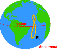
The analemma is a figure-8-shaped diagram that shows the declination of the sun (the angle that the sun is from the equator), for each day in the year. If you took a snapshot of the sun at the same time each day (from the same location), the Sun would make a figure shaped like an analemma during the course of a year (this is because the Earth is tilted on its axis and because it doesn’t orbit the Sun in a perfect circle).
An astrolabe is an instrument that was used to determine the altitude of objects (like the sun) in the sky. It was first used around 200 B.C. by astronomers in Greece. The astrolabe was replaced by the sextant.
A buccaneer was a pirate from the Caribbean.
A cape is a piece of land that that projects out into a large body of water.
A cartographer is a map maker.

Cartography is the study and the construction of maps.
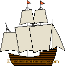
A caravel is a type of two- or three-masted sailing ship developed in the 1400s by the Portuguese.
Celestial navigation is a method of navigating by using the stars or other objects in the sky.
A chronometer is a very accurate time-keeping device that is used for determining one’s longitude at sea.
To circumnavigate is to travel around the entire Earth (or around another given object).

A compass is a device that always points north. It is used for navigation.
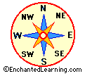
A compass rose is a design on a map that shows direction. It points which way is north, south, east, west, and some intermediate directions on the map.
The conquistadors were Spanish conquerors/explorers who sailed to the Americas to obtain gold, silver, and other treasures. They were often brutal and resorted to any means to get what they wanted.
The Earth’s land masses are divided into 7 large landmasses called continents. The Earth’s current continets are: Africa, Antarctica, Asia, Australia, Europe, North America, and South America.
Dead reckoning is a method of navigation that involves calculating one’s position by noting one’s speed, the speed and direction of the wind, ocean currents, and compass directions. Dead reckoning was used by sailors like Columbus.
The doldrums are a belt of very still air near the equator that stalled sailing ships. The doldrums are located between 5 degrees north and 5 degrees south of the equator. The doldrums ar also known as the Intertropical Convergence Zone (or ITCZ).
The Eastern Hemisphere consists of Europe, Asia, and Africa.

The equator is an imaginary circle around the earth, halfway between the north and south poles.
A fathom is a unit of measurement used on the seas to measure depth. A fathom is equal to 6 feet or 1.8 meters (it was originally the distance between a sailor’s outstretched arms).
Flotsam is a term for floating remnants of a shipwreck.
Geography is the study of the Earth’s surface.
A glacier is a slowly-moving river of snow and ice.
GPS is short for global positioning system. GPS devices tell you your exact longitude and latitude (it gets the information from orbiting satellites).
The horse latitudes are high-pressure areas, located between 30 degrees north and south, in which the wind is light and varied.
An icebreaker is a ship that is designed with a very strong hull and powerful engines so that the ship can travel through icy waters.
The International Date Line (IDL) is an imaginary north-south line (at the 180th meridian) in the Pacific Ocean at which the date changes. The east side of the IDL is a calendar day earlier than the west side. The actual IDL used is not a straight line, but zigzags around certain populated areas.

International marine signal flags are a system of flags used to communicate at sea. You can spell out your message, but there are also some shorthand meanings. For example, “DX” means “ship is sinking,” “C” means “yes,” and “N” means “no.”
Jetsam is a term for objects that have been thrown overboard in order to lighten a ship when it is in trouble (like when it hits a coral reef or comes too close to shore).
A knot is a unit of speed used on the water. A knot is equal to 1.15 miles per hour (or one nautical mile per hour).
Landfall means to approach, sight, or reach land.

Latitude is the angular distance north or south from the equator to a particular location. The equator has a latitude of zero degrees. The North Pole has a latitude of 90 degrees North; the South Pole has a latitude of 90 degrees South.

Longitude is the angular distance east or west from the north-south line that passes through Greenwich, England, to a particular location. Greenwich, England, has a longitude of zero degrees. The farther east or west of Greenwich you are, the greater your longitude (east or west). The Midway Islands (in the Pacific Ocean) have a longitude of 180 degrees (they are on the opposite side of the globe from Greenwich).
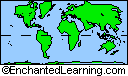
A map is a representation of a place. There are many different types of maps that have different uses.
A Mercator projection is a type of map in which the true compass direction are kept intact (lines of latitude and longitude intersect at right angles), but areas are distorted (for example, polar areas look much larger than they really are). Mercator Projections are useful for nautical navigation. Geradus Mercato first devised this projection for navigation in 1569.
A nautical mile is a unit of distance that is used on the water; it is equal to 1.15 miles or one minute (1/60 of a degree) along a line of longitude.
Navigation is process of plotting or directing the course of a vessel.
The New World is another name for the Americas (or the Western Hemisphere).
A water route connecting the Atlantic Ocean and the Pacific Ocean across northern Europe and Asia.
The Northern Hemisphere is the half of the Earth that is north of the equator.
The North Magnetic Pole is the point on the Northern Hemisphere of the Earth toward which a compass’ needle always points; at the North Magnetic Pole, a compass’ needle will stand vertically. It is now located near in northern Canada (and its location changes over time).

The North Pole is the northernmost place on Earth. There is no land at the North Pole, but there is a layer of ice on top of the Arctic Ocean around the pole.
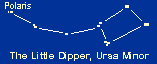
The north star is a star that is located almost due north and is useful for navigation. Polaris is currently the pole star of the Northern Hemisphere.
A water route connecting the Atlantic Ocean and the Pacific Ocean across northern North America.
The Old World is another name for the Eastern Hemisphere (Europe, Asia, and Africa).
A pole star is a star that is located almost due north or due south, which makes it useful for navigation. Polaris is the pole star of the Northern Hemisphere. There is no pole star for the Southern Hemisphere; the constellation Crux, however, is around the south celestial pole.
A privateer is a private attack/raid ship working for a country, or a person working on that ship. Privateers were licensed to attack and take ships from countries at war with the sponsoring country.
The quadrant is an instrument used to measure altitude.
Rapids are parts of a river that are shallow, rocky, and have strong currents.
Scurvy is a disease caused by a lack of vitamin C. Many sailors on long trips got scurvy, which at first debilitates and then kills the victim. When the cause of scurvy was determined to be a dietary deficiency, limes and other foods high in vitamin C were brought on long sea journeys, putting an end to the problem of scurvy. Bringing limes aboard is why sailors used to be called “limeys.”
The sextant is an astronomical instrument that is used to determine latitude for navigation. It does this by measuring angular distances, like the altitude of the sun, moon and stars. The sextant was invented independently in both England and America in 1731. The sextant replaced the astrolabe. The word sextant comes from the Latin word meaning “one sixth.”
The silk road consisted of a few over-land trading routes between China and the West (Europe). The well-traveled paths run from China through Afghanistan and Iran to Southern Europe.
Sounding is a method of measuring the depth of a body of water by dropping a weight attached to a rope and letting it hit the bottom.
The Southern Hemisphere is the half of the Earth that is south of the equator.
The South Magnetic Pole is the point on the Southern Hemisphere of the Earth toward which a compass’ needle always points; at the South Magnetic Pole, a compass’ needle will stand vertically. It is now located just off the coast the continent of Antarctica (and its location changes over time).

The south pole is the southernmost point on the Earth; it is located on the continent of Antarctica.
A strait is a narrow channel of water that connects two larger bodies of water.
A submersible is a small underwater vessel.
The summit is the highest point of a mountain (or other elevated area).
The trade winds (also called the trades) are strong easterly winds that blow through the tropics and subtropics. They blow from the northeast in the Northern Hemisphere and from the southeast in the Southern Hemisphere.
The Western Hemisphere is another name for the Americas (or the New World).
The westerlies are west-to-east winds that dominate the middle latitudes of both hemispheres on Earth. These winds blow between 35 degrees and 55 degrees of latitude.